

Wee Waa, lower Namoi valley
Introduction
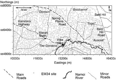
The study area is roughly centred on a small township of Wee Waa (Longitude 149o30’, Latitude -30o15’), located in the lower Namoi valley of northern New South Wales. The area covers approximately 2,048 km2.
Climate
The climate is typical of a semi-arid environment with a mean annual rainfall of 492 mm and potential evaporation of over 1,800 mm annually. The rainfall is slightly summer dominated with a mean maximum in January (79.8 mm) and a minimum in August (37.5 mm). Temperature varies from a mean maximum in January (35.3 oC) to minima in July (17.0 oC). Potential evaporation is greatest in January and lowest in July.
Agriculture
The area includes both irrigated and dryland farms. The latter is mostly wheat (Triticum aestivum L.) production and native pastures for beef cattle and wool production. Irrigation is mostly for cotton (Gossypium hirsutum L.) production.
Physiography
Stannard and Kelly (1977), in a reconnaissance soil survey of this part of the lower Namoi valley, identified five physiographic units, namely: the clay plains, prior stream formations, coarse-textured dissected flood plain, Pilliga scrub complex, and Edgeroi scrub plain.
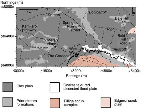
The predominant clay plains are generally uniform in topography except where dissected by present streams. The uppermost sediments are fine-textured upon which a self-mulching clay soil has developed.
The prior stream formations occur mostly in continuous belts of slightly elevated and undulating land, the uppermost materials of which are coarser than those of the clay plains. The prior stream channels may be distinguished from the levees, with the former underlain by coarse channel sediments.
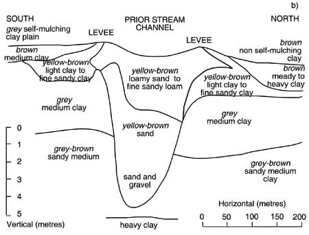
In some areas, the stream channels are located in areas that are low-lying relative to the plain, where they act as preferential paths for floodwaters. In these areas, the upper sediments are of a fine texture and are identifiable from the normal effluent by their wide meander belts and broad and shallow channels.
The coarse-textured dissected low floodplains, which lie adjacent to the Namoi River between Narrabri and Wee Waa, are usually shallow depressions often dissected by small flood channels.
Much of the materials are coarse-textured which originated from the Pilliga Scrub as a result of the incision by the prior stream. Elsewhere, the low-lying formation associated with the river and effluents are uniformly textured (Stannard and Kelly, 1977).
Hydrogeology
The hydrogeological units in the area encompass two of the three major types of rock formations that can yield useful quantities of water (i.e. aquifers). That is, water can be obtained from unconsolidated sediments and sedimentary rocks, although water is available from fractured rocks to the east of the study area.
The hydrogeological map also shows the salinity yield of the surficial aquifer systems (< 25 m) (Department of Water Resources, 1988).
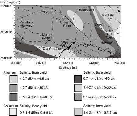
The alluvial sediments located in the eastern half of the area are generally Mid-Miocene (15 million years BP) to Recent Age deposited by the ancient and present day Namoi River and its major tributaries. Layers of clean sand and gravel separated by clay, silt and sandy lenses form the aquifers.
The largest of the alluvial aquifers gives the highest water yield (>50 L/s) of good quality (<0.7 dS/m). One of the smaller alluvial aquifers is the most saline (i.e. 2.1-4.2 dS/m), yielding 5-50 L/s.
Colluvial aquifers dominate the eastern areas. These formations are of recent age with a few remnants of older formations and were formed as a result of in situ weathering products overlying a variety of rock types some of which were deposited by the minor tributaries. They produce lower water yield (0.5-5 L/s) than the alluvial aquifers with their salinity levels ranging from 0.7 to 1.4-2.1 dS/m.
The sedimentary rocks consist of undifferentiated Lower Mesozoic and Paleozoic Rocks varying in age from Triassic (230 million years BP) to Permian (280 million years BP). These rocks are limited to the southeastern part of the area. They occur below the sedimentary rocks of the Great Artesian Basin.
The water is generally suitable for most purposes, although water yields are generally less than 0.5 L/s. The fractured rocks are of Early Miocene age (18 million years BP) and were formed from extensive basalt flows. Today, outcrops are apparent in the eastern areas on the footslopes of the Nandewar Range.
Acknowledgments
As part of a larger Cotton Research and Development Corporation Project entitled “Understanding the salinity threat in the irrigated cotton growing areas of Australia: Phase 2 – Methods and Techniques,” research was started in the area around Wee Waa in 1998 in collaboration with the Coordinating Committee of Lower Namoi Valley Water Users Association. The project was funded as part of the Natural Heritage Trust (NW 1082.98) and was entitled “Determine salinity threat in irrigated cotton in upper and lower Namoi valley.”
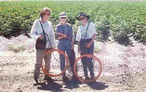
EM34 Survey
In this study, a broad-scale EM survey is undertaken using an EM34 instrument across the Myall Vale, Wee Waa and Merah North areas in the lower Namoi valley. With respect to the EM34, signal readings are taken at 10 (EM34-10), 20 (EM34-20) and 40 m (EM34-40) coil spacing in the horizontal dipole mode.
EM34 measurements were made on a grid of approximately 1 km spacing. A Magellan NavPro5000 GPS was used to provide positional information.
In total 204,800 hectares was covered. The main land use includes irrigated cotton production, dryland cropping (i.e. wheat) and grazing. Measurements were also made within the network of stock routes and native woodland areas. A total of 1,869 EM34-3 survey points were visited.
References
Department of Water Resources-Narrabri Hydrogeological Map 1988. Department of Water Resources, NSW.
Stannard ME Kelly ID 1977. ‘The irrigation potential of the lower Namoi valley,’ Water Resources Commission, NSW.
Further Reading
Triantafilis J Odeh IOA Minasny B and McBratney AB 2003. Elucidation of physiographic and hydrogeological units using fuzzy k-means classification of EM34 data in the lower Namoi valley. Environmental Modelling and Software 18, 667-680.
Triantafilis J Odeh IOA Warr B and Ahmed MF 2004. Modeling and mapping the impact of saline water use in the lower Namoi valley. Agricultural Water Management 69, 203-231.
© Copyright UNSW 2007 | Terms of use | Privacy Policy