

Bourke, Darling River valley
Introduction
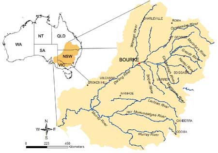
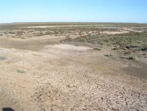
The study area is centred southwest of the township of Bourke (longitude 145o 56’E, latitude 30o 06’S) and is located in the lower Darling River valley.
Climate
The climate is typical of a semi-arid environment with a mean annual rainfall of 355 mm and potential evaporation of over 2,000 mm annually. The rainfall is slightly summer dominated with a mean maximum in February (42.2 mm) and a minimum in April (12.8 mm). Temperature varies from a mean maximum in January (36.3 oC) to minima in July (4.6 oC). Potential evaporation is greatest in January and lowest in July.
Agriculture
Owing to the low rainfall and high evaporation irrigation was introduced in the early 1960’s. Today the Bourke Irrigation District (BID) includes over 10,000 ha of developed land. Predominantly, cotton (Gossypium hisutum) is grown in rotation with wheat (Triticum aestivum) and a nitrogen fixing legume crop (e.g. Dolichus lab lab).

Physiography
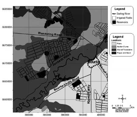
The land surface is generally flat and characterized by unconsolidated tertiary alluvium. The physiography is dominated by four units; Alluvial floodplain, Plains, Playa basin and Aeolian dune (NRPC 2004).
Soil
Northcote (1966) identified five soil map units (Figure 2b). This includes; uniform textured-deep yellow grey self-mulching clays (II1) and -grey self-mulching cracking clays (CC19), gradational profiles with-neutral reaction trend (My1) and -alkaline reaction trend (Mx1), and duplex profiles with red clay subsoil (Nb4).
The predominant yellow grey self-mulching cracking clays (II1) characterize the Alluvial floodplains and terraces and associated undulating areas along former and present drainage ways.
The grey self-mulching clay (CC19) is slightly gilgaied and associated with major and minor functional and non-functional drainage-ways and swampy Playa basins.
The red earth with neutral reaction trend (My1) occurs in gently to strongly undulating tableland and remnants. The red earths with alkaline reaction trend (Mx1) occur on undulating plains with low Aeolian dunes and low stony ridges. Associated are dunes of variable frequency with drainage lines containing clay plains.
The duplex red earth (Nb4) characterizes wind deflated areas and occasionally low sand dunes.

Geology
From a geological stand point the BID is situated in the Eromanga basin, which is characterized by terrestrial sequences of the Jurassic period followed by shallow marine and lacustrine influences of the Cretaceous.
The hydrogeology of the BID is dominated by the Bourke Graben which was formed by a period of down-warping.
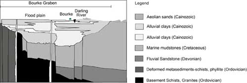
The lowest unit (Ordovician-Basement and -Metasediments) is comprised of highly sheared and contorted rocks. These sediments (i.e. phyllite, schists, conglomerate and sandstones) form a single ridge and the hydrological basement.
Massive fluvial deposits (Devonian) overlie this unit at depths ranging from 150 to 300 m below sea level. These contain aquifers that form part of the Great Artesian Basin and are the highest yielding water bodies.
The fluvial deposits are overlain by Cretaceous marine mudstones, which can be up to 300 m thick. Groundwater yield is low (i.e. < 1L/sec) and highly saline (i.e. > 14,000 mg/L TDS).
The marine mudstone approaches the land surface in the north-east part of the geological transect. This coincides with the northern part of the BID, underlying the CC19 soil map unit and is associated with the Playa basin.
Cenozoic alluvial deposits occur widely throughout and subdue the more rugged Cretaceous landscape.
These sediments are a key element to the local hydrology. The inter-bedding of sands within the clay units provide a means for groundwater to interact with the Darling River and consequently allow infiltration and dilution of the high levels of salinity associated with the Cretaceous marine mudstones (Williams 1993).
Land management issues
The introduction of irrigated agricultural production and the inherently saline sub-surface sediments has led to isolated instances of point-source salinisation across the BID, which have been managed successfully using various engineering and land management solutions.
Acknowledgments
As part of a larger Cotton Research and Development Corporation Project entitled “Understanding the salinity threat in the irrigated cotton growing areas of Australia: Phase 3 – Implementation and Management,” research was started in the Bourke Irrigation District in 1999 in collaboration with the Bourke Irrigators Association. The project was funded as part of the Natural Heritage Trust (WN0688.99) and was entitled “Determine causes & controls of salinity in irrigated farming systems.”
EM survey
In this study, a broad-scale EM survey is undertaken using an EM34 and EM38 instruments across the Bourke Irrigation District (BID). With respect to the EM34, signal readings are taken at 10 (EM34-10), 20 (EM34-20) and 40 m (EM34-40) coil spacing in the horizontal dipole mode. EM38 signal data is also collected using the instrument in the vertical (EM38-v) and horizontal (EM38-h) modes of operation.
EM34 and EM38 signal readings are made on an approximate 500 m grid in irrigated areas and at an interval of 1 km in dryland areas across the BID. A total of 1,236 measurements are made and at each site a Magellan NavPRO5000 is used to obtain a GPS location in the Geocentric Datum of Australia 1994 (GDA94).

References
Northcote KH 1966. Atlas of Australian Soils, Sydney-Canberra-Bourke-Armidale Area. CSIRO and Melbourne University Press, Melbourne, Australia.
NRPC 2004. Vegetation communities of the northern floodplains of western New South Wales, Book 3: North Eastern section of Bourke Shire, Northern Rivers Planning Community, Walgett, NSW.
Williams RM 1993. Saline Groundwater Inflows to the Darling River at 'Glen Villa" Near Bourke, NSW. Department of Water Resources.
© Copyright UNSW 2007 | Terms of use | Privacy Policy